


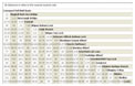
Maghull to Burscough
12- 24 miles
Burscough
to Wigan
24 - 34 miles
Former Lancaster
Canal South
37-47miles
Johnson's Hillock
to Cherry Tree
47 - 54 miles
Towpath Treks
Leeds & Liverpool Canal Cycling Guide
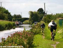
The Leeds - Liverpool Canal is popular with cyclists and work is being done to make it even more accessible to cyclists. Some of the towpath is part of the National Cycle Network.
Planning the Trip
The Route: 127.25 miles of towpath
The canal was originally 127.25 miles long, the first quarter of a mile at Liverpool has been filled in but it is still possible to ride along the route to today's terminus at Eldonian Village. Both ends of the canal are close to the main railways stations of Leeds and Liverpool. It is possible to cycle along the towpath along the whole canal, the only exceptions are the two tunnels, Gannow and Foulridge. At the tunnels you will have to find your way over the top to meet the canal at the other side. There arent many junctions to confuse you, the Walton Summit Branch might throw you but it is only a quarter of a mile long! If you dont want to get lost cross the bridge by the junction and follow the canal to the right up past the locks.
Most people cycle from Liverpool to Leeds. Its said that the wind will be behind you if you go that way. Also the Leeds end is a lot nicer than the Liverpool end so you end at the nice bit if you go that way.
I am creating google maps of the canal and hopefully these will help with your planning.
The Nicholson's Guides are useful for cyclists as well as boaters. I recommend them for any trip to the canal.
How far to go?
 I have created a canal mile matrix to help you work out distances along the canal. Whether you are going all the way or just a short ride I hope it is useful.
National Cycle Network Routes
The Leeds Liverpool Canal and its towpath links up with some of the national cycle routes. Part of the western end of the canal around Maghull is on Route 62, the Trans Pennine Trail from Southport to Selby. National Route 6 runs from Blackburn to Accrington including the towpath between Blackburn and Rishton. National Route 68, the Pennine Cycleway, goes through Burnley, Barnoldswick and Gargrave. National Route 69 covers the towpath from Stockbridge to Shipley and the towpath to Leeds continues as Route 66, the White Rose Cycle Route on the Aire Valley Towpath. For more information on the national cycle network look at sustrans.org.uk
Getting to the Canal
By Train
 Both ends of the canal are close to the main railway stations in Leeds and Liverpool. Along the canal there are stations along the route. Click the link on the left to see where the stations are and how to get from them to the canal.
By Car
There are lots of places to park along the canal. There are car parks beside the canal itself or at railway stations. There is on street parking too. Map with some car parks.
On the towpath
Towpath Etiquette
Read the Canal and River Trust pages on cycling here. Slow down or dismount at bridges. When approaching a bridge you cannot always see if anyone is coming the other way and the towpath is not wide enough to allow people and bikes to pass. Remember pedestrians have right of way. In some sections the towpath is narrow so you will have to stop when passing people. Don't expect people to get out of your way, they might not 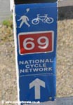 throw themselves in the canal or a hedge to let you pass. Cyclists along with walkers, dog owners, young people and fishermen are unpopular with boaters so try to ensure you act responsibly and don't give them anything else to moan about.
Towpath Conditions
 The quality of the towpath varies from tarmac cycle paths to thick muddy puddles. There are only a few short sections which could be a problem for cyclists but you can always walk your bike past these. The weather can change the towpath, I would avoid cycling after heavy rain.
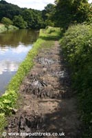
I have cycled half way along the Rufford branch from the Junction. The towpath is not suitable for cycling. The towpath is muddy and narrow in places. Sometimes the towpath is lower than the water level.
Around Blackburn and Burnley the towpath has been improved. The new signs around Blackburn suggest the council is encouraging people to use the towpath.
During the winter months some sections of towpath may be closed off while work is carried out. A list of stoppages can be found online and its worth checking before you set out. CART list stoppages here.
Towpath Gates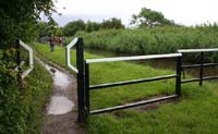
Some sections have gates and barriers to stop motorbikes getting on the towpath. These are a pain for cyclists but can be overcome.
There is a gap for bikes but this may be difficult for bikes with wide handlebars or bar-ends.
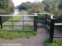
Some people pass the bike around the edge of the gate over the canal. Make sure you don't have anything that will fall in if you are doing this.
Cycle Equipment
I would recommend mountain bikes or trail bikes for the towpath and a mudguard.
Cyclists should GET A BELL or be prepared to shout a warning to walkers who often wont hear you approach from behind until you are right on top of them.
A puncture repair kit or spare inner tube and pump can handy too, its a long walk back with a flat tyre as I know from experience. The hedge alongside the towpath is often hawthorn, and when these are trimmed the towpath gets covered in thorns. There are also the usual nails and glass that you get anywhere else.
Take plenty of water with you, you might find it hard to refill on route.
You can get a facilities key from British Waterways which will give you access to the showers, toilets, water points etc on the canal network. They are meant for boaters but... you can buy them online here:
https://secure.britishwaterways.co.uk/shop
Glasses, you are riding between water and a hedge so lots of flying things live there.
Track your Progress
Let friends and family follow you online with this site: http://www.runtastic.com/ sure there are similar sites about.
How long will it take?
Everyone will have a different style of riding and different abilities. Colin Dobson rode from Leeds to Liverpool and back in 22 hours 38 minutes. Let me know how long you took to do the ride so I can work out an average time. People seem to do it in two or three days.
Take Advice!
Why not take the time to read these blogs and sites that others have written about cycling on the canal.
Blogs
- Leeds to Liverpool Cycle Ride Blog Photos and comments of a 3 day trip from Leeds to Liverpool in 2007
- teamaldi.blogspot.com Team Aldi cycled from Liverpool to Leeds in one day in 2007.
- www.washingtonimaging.co.uk Notes on a ride from Skipton to Leeds in Jan 2008 on folding Brompton bikes
- www.goatchurch.org.uk One couples trip from Liverpool to Leeds in 2000
- pedalpressure.blogspot.com A cyclists blog
- liverpool2leeds.blogspot.com One day ride from Liverpool to Leeds in 2009
- colindobson.blogspot.com Lots of helpfull advice on riding from Leeds to Liverpool and back in two days in 2009
- llcanal.blogspot.com Cyclist planning and training for the one day ride in 2010
- loulouk.pegden.com Canal bike ride from Liverpool to Leeds in 2010
- shipleyceprimary.primaryblogger.co.uk Liverpool to Leeds in 2011
- www.pendleslotracingclub.co.uk.../leeds-liverpool-canal.htm Liverpool to Leeds in July 2011
- leeds-liverpoolcanal.blogspot.com Liverpool to Leeds in 2011 in 3 days
- hop3y.com Liverpool to Leeds on Sept 6th 2011
- canalcommute.blogspot.co.uk Liverpool to Leeds on July 29th 2012
- canalventures.blogspot.co.uk Liverpool to Leeds in 2015
Websites
- canalrivertrust.org.uk The official site for cycling on the Leeds Liverpool Canal
- http://canalrivertrust.org.uk/see-and-do/cycling
- Sustrans: Route 810 includes canal at Litherland A map of cycle route along the canal at Litherland
- www.airevalleytowpath.org.uk covers the towpath between East Marton and Leeds.
- www.ctc.org.uk the UK’s National Cyclists’ Organisation
- Video of cyclists on tour and passing a canal in 1956
- www.cyclechat.net A forum for cyclists.
- www.justgiving.com if you are collecting money for charity
- http://uk.virginmoneygiving.com/giving/ another charity collection site.
Help!
Help me help other cyclists. Lots of people email me with questions about cycling along the canal. If you have any advice for cyclists send me an email and I will add it to this page. Why not write a blog about your ride, blogger.com is easy to use. People do like to read about other peoples rides before they set out.
Be Sociable
If you are doing the ride or preparing for it send me a tweet to @towpathtreks and I will retweet any charity links or anything likely to help others. Or just say hello.
Or say hello on facebook: http://www.facebook.com/towpathtreks
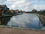
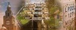
Liverpool (canal terminus) Church (halfway point) Leeds (River Lock)
Other Canals to Cycle
- The old Chester Canal from Ellesmere Port to Chester (see my canal page)
- The Regent's Canal: Limehouse to Little Venice (see my canal page)
Shipley to Leeds
115 -125 miles
Stockbridge to Shipley
109 -115 miles
Skipton to Stockbridge
99 - 109 miles
Gargrave to Skipton
93 -99 miles
Greenberfield to Gargrave
87 - 93 miles
Foulridge to Greenberfield
82-87 miles